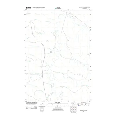
2011 Map of Fighting Butte
USGS Topo · Published 2011About this map
Fighting Butte rises as a prominent landmark in this corner of Powder River County, overseeing a complex network of waterways that define the regional geography. The Little Powder River serves as the primary drainage, winding through the center of the sheet and gathering numerous tributaries such as Rough Creek and Fighting Butte Creek. This landscape is marked by the transition of prairie into dissected drainages, where early water management is evidenced by the Waite Ditch near the East Fork Little Powder River. Long-established ranching routes follow the natural contours of the land, with Highway 59 providing the main north-south artery through this ranching country. The map captures the intricate drainage patterns of smaller seasonal flows like Skunk Creek and Tiret Creek, which are critical to understanding the historical use of this open range.
Find a feature on this map
20 named features on this map. Tap any name to fly to it.
Don’t see what you’re looking for? This feature index may not catch every label — zoom into the map to look around manually.
Map Details
Editions of this 2011 Fighting Butte Map
This is the sole edition of this map. No revisions or reprints were ever made.
Other maps of this area

1954 · Ekalaka
USGS Topo · 1:250,000

1956 · Ekalaka
USGS Topo · 1:250,000

1958 · Ekalaka
USGS Topo · 1:250,000

1965 · Ekalaka
USGS Topo · 1:250,000

1970 · Pine Creek
USGS Topo · 1:24,000

1970 · Sanburn Reservoir
USGS Topo · 1:24,000

1970 · Bear Skull Mountain
USGS Topo · 1:24,000

1973 · Monday Creek
USGS Topo · 1:24,000
1973 · Fighting Butte
USGS Topo · 1:24,000
1973 · Eldon Mountain
USGS Topo · 1:24,000