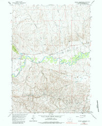
1961 Map of Figure 8 Reservoir
USGS Topo · Published 1984About this map
The Powder River meanders through this portion of Johnson County, defining a landscape of ranching and early petroleum development in the early 1960s. The northern banks are dotted with established family holdings like the Mayor Ranch, Streeter Ranch, and Indart Ranch, many of which utilized an Irrigation Canal to support livestock in the arid Wyoming terrain. This ranching culture is anchored by local landmarks such as the Sutton Sch and the Pioneer Monument, reflecting the deep-rooted settlement history of the region.
Find a feature on this map
34 named features on this map. Tap any name to fly to it.
Don’t see what you’re looking for? This feature index may not catch every label — zoom into the map to look around manually.
Map Details
Editions of this 1961 Figure 8 Reservoir Map
2 editions found
Other maps of this area

1955 · Arminto
USGS Topo · 1:250,000

1958 · Arminto
USGS Topo · 1:250,000

1961 · Soldier Creek
USGS Topo · 1:24,000

1961 · Kaycee NE
USGS Topo · 1:24,000

1961 · Fourmile Reservoir
USGS Topo · 1:24,000

1961 · Figure 8 Reservoir
USGS Topo · 1:24,000

1961 · Dry Creek Reservoir
USGS Topo · 1:24,000

1961 · Dugout Ranch
USGS Topo · 1:24,000

1961 · Dead Woman Crossing
USGS Topo · 1:24,000

1961 · Wall Creek
USGS Topo · 1:24,000