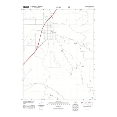
2011 Map of Fillmore
USGS Topo · Published 2011About this map
Fillmore serves as the focal point of this Millard County landscape, situated at the transition where the valley floor meets the rising terrain of the Pavant Range. The town's grid is established between the watercourses of Chalk Creek and Pine Creek, with local civic landmarks like the Fillmore Post Office and the expansive Fillmore Cemetery providing anchors for genealogical research. The map illustrates a community shaped by its water management, featuring a network of irrigation and drainage infrastructure including the Sink Ditch. To the east, the geography becomes increasingly complex as it climbs toward Mine Camp Peak. Canyons and pastures such as Mountain Sheep Canyon and Deer Pasture indicate the long-standing ranching and livestock heritage of the region, while recreation sites like the Meadow Creek Campground and Wagons West RV Campground highlight the area's modern role for travelers along the Interstate 15 corridor.
Find a feature on this map
42 named features on this map. Tap any name to fly to it.
Don’t see what you’re looking for? This feature index may not catch every label — zoom into the map to look around manually.
Map Details
Editions of this 2011 Fillmore Map
This is the sole edition of this map. No revisions or reprints were ever made.
Other maps of this area

1885 · Beaver
USGS Topo · 1:250,000

1885 · Sevier Desert
USGS Topo · 1:250,000

1953 · Richfield
USGS Topo · 1:250,000

1953 · Delta
USGS Topo · 1:250,000

1958 · Richfield
USGS Topo · 1:250,000

1958 · Delta
USGS Topo · 1:250,000

1960 · Meadow
USGS Topo · 1:24,000

1961 · Fillmore
USGS Topo · 1:24,000

1961 · Mt. Catherine
USGS Topo · 1:24,000

1961 · Richfield
USGS Topo · 1:62,500