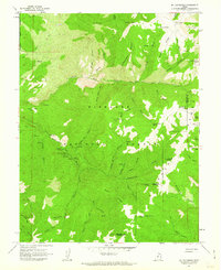
1961 Map of Mt. Catherine
USGS Topo · Published 1963About this map
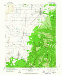
Fishlake National Forest encompasses the vast majority of this 1961 survey, revealing a landscape defined by sharp ridges and deep canyons within the Pavant Range. The map illustrates a developed mid-century recreational infrastructure, specifically concentrated along the South Fork Chalk Creek. Here, a string of designated sites such as Copleys Cave Picnic Area, Shingle Mill Picnic Area, and Balsam Picnic Area suggests a well-traveled corridor for local forest visitors. High peaks like Mt Catherine and Jacks Peak VABM 10072 anchor the northern terrain, while the administrative presence of the forest service is marked by the Indian Springs Guard Station and Solitude Guard Sta. A network of primitive paths and jeep trails connects these remote outposts, tracing routes through Hardscrabble Canyon and along Hans Ridge.
Find a feature on this map
59 named features on this map. Tap any name to fly to it.
Don’t see what you’re looking for? This feature index may not catch every label — zoom into the map to look around manually.
Map Details
Editions of this 1961 Mt. Catherine Map
2 editions found
Other maps of this area

1885 · Beaver
USGS Topo · 1:250,000

1885 · Sevier Desert
USGS Topo · 1:250,000

1953 · Richfield
USGS Topo · 1:250,000

1953 · Delta
USGS Topo · 1:250,000

1958 · Richfield
USGS Topo · 1:250,000

1958 · Delta
USGS Topo · 1:250,000
1961 · Fillmore
USGS Topo · 1:24,000
1961 · Richfield
USGS Topo · 1:62,500

1962 · Delta
USGS Topo · 1:250,000
1962 · Fillmore
USGS Topo · 1:62,500