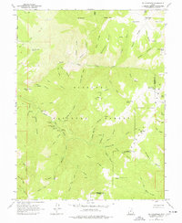
1961 Map of Mt. Catherine
USGS Topo · Published 1977About this map
Fish Lake National Forest and the Pavant Range dominate this mid-century topographic study, which defines the high-altitude landscape along the border of Millard and Sevier Counties. The drainage patterns of the North Fork Chalk Creek and South Fork Chalk Creek dictate the local geography, carving deep corridors like Shingle Mill Canyon and Copley Canyon. For those interested in early forest recreation and management, the map identifies several mid-century recreation sites including the Shingle Mill Picnic Area, Buckskin Charley Picnic Area, and Pistol Rock Picnic Area. This period of forest administration is further marked by isolated outposts such as the Indian Springs Guard Station and Solitude Guard Sta. The map's high points, reaching from Mt Catherine to Willow Creek Peak, are connected by primitive transportation routes, primarily a network of Jeep Trails and unnamed paths that provided essential access for grazing and forest service operations.
Find a feature on this map
70 named features on this map. Tap any name to fly to it.
Don’t see what you’re looking for? This feature index may not catch every label — zoom into the map to look around manually.
Map Details
Editions of this 1961 Mt. Catherine Map
2 editions found
Other maps of this area

1885 · Beaver
USGS Topo · 1:250,000

1885 · Sevier Desert
USGS Topo · 1:250,000

1953 · Richfield
USGS Topo · 1:250,000

1953 · Delta
USGS Topo · 1:250,000

1958 · Richfield
USGS Topo · 1:250,000

1958 · Delta
USGS Topo · 1:250,000

1961 · Fillmore
USGS Topo · 1:24,000

1961 · Mt. Catherine
USGS Topo · 1:24,000

1961 · Richfield
USGS Topo · 1:62,500

1962 · Delta
USGS Topo · 1:250,000