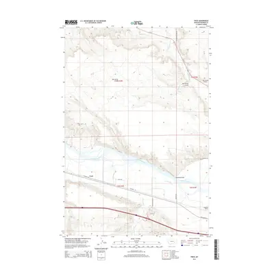
2014 Map of Finch
USGS Topo · Published 2014About this map
The Yellowstone River cuts a wide path through this portion of Rosebud County, defining the valley floor where the small settlements of Finch and Hammond Valley are situated. This modern survey illustrates how transportation has historically clung to the river's path, with Frontage Rd and the remnants of Old Highway 10 paralleling the water. To the north, the terrain rises into broken uplands carved by West Spring Coulee and East Spring Coulee, while Big Porcupine Cr flows southward from the hills toward the main river channel. Genealogists and local historians will find the Howard Cem located just north of the interstate corridor, near the transition into Howard Valley. The map detail captures a landscape of cattle ranching and river-bottom agriculture, where roads like Reservation Creek Rd and Walter Rd connect isolated homesteads to the primary transit arteries.
Find a feature on this map
23 named features on this map. Tap any name to fly to it.
Don’t see what you’re looking for? This feature index may not catch every label — zoom into the map to look around manually.
Map Details
Editions of this 2014 Finch Map
This is the sole edition of this map. No revisions or reprints were ever made.
Other maps of this area

1954 · Forsyth
USGS Topo · 1:250,000

1957 · Forsyth
USGS Topo · 1:250,000

1958 · Forsyth
USGS Topo · 1:250,000

1960 · Vananda
USGS Topo · 1:24,000

1960 · Sanders
USGS Topo · 1:24,000

1968 · Donleys Reservoir
USGS Topo · 1:24,000

1968 · Nichols
USGS Topo · 1:24,000

1968 · Finch NE
USGS Topo · 1:24,000

1968 · Finch
USGS Topo · 1:24,000

1971 · Griffin Coulee NE
USGS Topo · 1:24,000