1979 Map of Fine Creek Mills
USGS Topo · Published 1982About this map
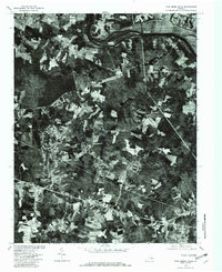
Fine Creek Mills and the winding course of the James River define this 1979 orthophotograph of Powhatan County. This unique imagery, produced through optical scanning of aerial photography, provides a literal view of the landscape rather than a standard topographic drawing. The wooded terrain is broken by clearings for agricultural fields and developing residential pockets like Holly Hills and Red Lane. Water sources are central to the settlement pattern, from the prominent Lake Shawnee to the smaller Woodberry Pond and several named tributaries including Dutoy Creek and Ones Creek. The orthophoto format allows researchers to examine precise vegetation boundaries and land use at Flat Rock during the late 1970s, capturing the transition between traditional rural life and modern subdivisions.
Find a feature on this map
11 named features on this map. Tap any name to fly to it.
Don’t see what you’re looking for? This feature index may not catch every label — zoom into the map to look around manually.
Map Details
Editions of this 1979 Fine Creek Mills Map
This is the sole edition of this map. No revisions or reprints were ever made.
Other maps of this area

1890 · Goochland
USGS Topo · 1:125,000

1892 · Goochland
USGS Topo · 1:125,000

1897 · Amelia
USGS Topo · 1:125,000

1943 · Goochland
USGS Topo · 1:31,680

1943 · Fine Creek Mills
USGS Topo · 1:31,680

1943 · Powhatan
USGS Topo · 1:31,680

1943 · Perkinsville
USGS Topo · 1:31,680

1943 · Hallsboro
USGS Topo · 1:31,680

1943 · Clayville
USGS Topo · 1:24,000

1943 · Midlothian
USGS Topo · 1:24,000