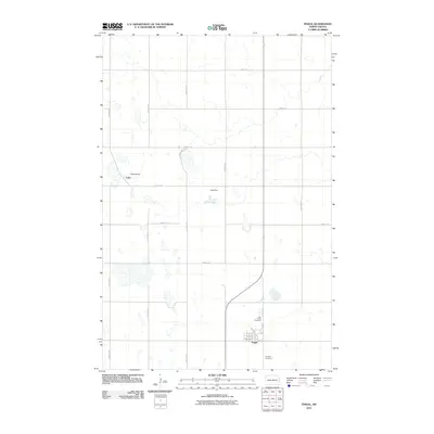
2011 Map of Fingal
USGS Topo · Published 2011About this map
Fingal sits at the heart of this Barnes County landscape, serving as a primary settlement within a grid of section-line roads. The town's layout is clearly defined by several local streets including 1st Ave and 1st St, with the Holy Trinity Cemetery and Hill Side Cemetery located on its northern and eastern outskirts respectively. The area is characterized by numerous small water bodies and wetlands, typical of the regional topography, with managed water features such as Triebold Dam and Cuba Dam providing essential water control near the small settlement of Cuba. This survey captures the rural character of the North Dakota plains at the start of the 21st century, showing how infrastructure like 42nd St SE and 128th Ave SE connects these isolated prairie communities.
Find a feature on this map
24 named features on this map. Tap any name to fly to it.
Don’t see what you’re looking for? This feature index may not catch every label — zoom into the map to look around manually.
Map Details
Editions of this 2011 Fingal Map
This is the sole edition of this map. No revisions or reprints were ever made.
Other maps of this area

1897 · Tower
USGS Topo · 1:125,000

1953 · Fargo
USGS Topo · 1:250,000

1956 · Fargo
USGS Topo · 1:250,000

1961 · Valley City East
USGS Topo · 1:24,000

1965 · Lucca
USGS Topo · 1:24,000

1965 · Tower City SW
USGS Topo · 1:24,000

1967 · Tower City
USGS Topo · 1:24,000

1967 · Fingal
USGS Topo · 1:24,000

1967 · Fingal SW
USGS Topo · 1:24,000
1967 · Oriska
USGS Topo · 1:24,000