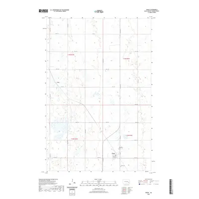
2020 Map of Fingal
USGS Topo · Published 2020About this map
Fingal serves as the primary hub of this eastern North Dakota agricultural landscape, where the town's grid meets the surrounding section lines of t138n r56w and t138n r57w. The map documents a classic Prairie settlement pattern, characterized by small population centers like Cuba and Fingal that formed along transportation corridors. Outside of the towns, the landscape is defined by its social infrastructure, notably the Holy Trinity Catholic Cem and Hill Side Cem, which offer significant research value for genealogists and local historians tracing families in Barnes County. The terrain is marked by numerous small depressions and wetlands, typical of the regional topography, which dictate the winding paths of rural roads between the strictly surveyed township and range boundaries.
Find a feature on this map
26 named features on this map. Tap any name to fly to it.
Don’t see what you’re looking for? This feature index may not catch every label — zoom into the map to look around manually.
Map Details
Editions of this 2020 Fingal Map
This is the sole edition of this map. No revisions or reprints were ever made.
Other maps of this area

1897 · Tower
USGS Topo · 1:125,000

1953 · Fargo
USGS Topo · 1:250,000

1956 · Fargo
USGS Topo · 1:250,000

1961 · Valley City East
USGS Topo · 1:24,000

1965 · Lucca
USGS Topo · 1:24,000

1965 · Tower City SW
USGS Topo · 1:24,000

1967 · Tower City
USGS Topo · 1:24,000

1967 · Fingal
USGS Topo · 1:24,000

1967 · Fingal SW
USGS Topo · 1:24,000
1967 · Oriska
USGS Topo · 1:24,000