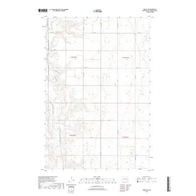
2018 Map of Fingal SW
USGS Topo · Published 2018About this map
The Sheyenne River cuts a deep, winding valley through this part of North Dakota, creating a distinct topographical break in the surrounding plains. This 2018 survey documents the varied landscape within t139n r58w and surrounding townships, where the river's path is followed by the N Country National Scenic Trail. This long-distance trail meanders through the valley, crossing near Sheyenne Valley Est, reflecting the area's modern role as a corridor for conservation and recreation. Away from the wooded river breaks, the map is dominated by a grid of rural roads like 38th St SE and 122nd Ave SE, illustrating the enduring Public Land Survey System that organizes the region's agricultural heartland. The contrast between the natural curves of the river valley and the rigid geometry of the upland section lines defines the physical character of this Barnes County territory.
Find a feature on this map
18 named features on this map. Tap any name to fly to it.
Don’t see what you’re looking for? This feature index may not catch every label — zoom into the map to look around manually.
Map Details
Editions of this 2018 Fingal SW Map
This is the sole edition of this map. No revisions or reprints were ever made.
Other maps of this area

1897 · Tower
USGS Topo · 1:125,000

1897 · Eckelson
USGS Topo · 1:125,000

1953 · Jamestown
USGS Topo · 1:250,000

1953 · Fargo
USGS Topo · 1:250,000

1956 · Fargo
USGS Topo · 1:250,000

1956 · Jamestown
USGS Topo · 1:250,000

1961 · Valley City East
USGS Topo · 1:24,000

1961 · Valley City West
USGS Topo · 1:24,000

1967 · Fingal
USGS Topo · 1:24,000

1967 · Fingal SW
USGS Topo · 1:24,000