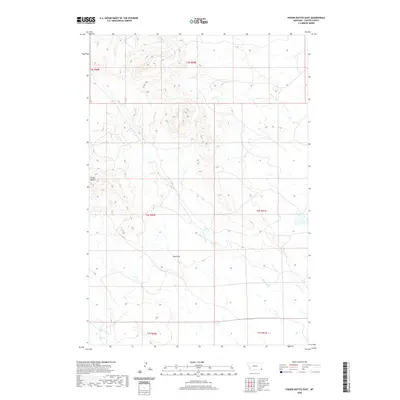
2020 Map of Finger Buttes East
USGS Topo · Published 2020About this map
The rolling drainage basins of eastern Carter County define this remote landscape, where the seasonal flow of Blacktail Cr carves its way through the high plains. Situated in the southeastern corner of Montana, this area is characterized by the expansive Public Land Survey System grids of T5S R59E and T6S R61E, reflecting the organized ranching and grazing tracts that have long supported the local agricultural economy. The terrain reveals a complex network of dry draws and ridges typical of the northern Great Plains, illustrating how water availability, or the lack thereof, has dictated the sparse settlement patterns in this part of the state. Map collectors and historians can observe the delicate intersection of section lines and natural hydrology in a region where traditional land use remains largely unchanged since the early frontier days.
Find a feature on this map
1 named feature on this map. Tap any name to fly to it.
Don’t see what you’re looking for? This feature index may not catch every label — zoom into the map to look around manually.
Map Details
Editions of this 2020 Finger Buttes East Map
This is the sole edition of this map. No revisions or reprints were ever made.
Other maps of this area

1954 · Ekalaka
USGS Topo · 1:250,000

1956 · Ekalaka
USGS Topo · 1:250,000

1958 · Ekalaka
USGS Topo · 1:250,000

1965 · Ekalaka
USGS Topo · 1:250,000

1980 · Prairie Dog Creek
USGS Topo · 1:24,000
1980 · Alzada NW
USGS Topo · 1:24,000

1980 · Cactus Creek West
USGS Topo · 1:24,000

1980 · Finger Buttes East
USGS Topo · 1:24,000
1980 · Albion
USGS Topo · 1:24,000
1980 · Capitol NW
USGS Topo · 1:24,000