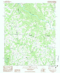
1983 Map of Fingerville East
USGS Topo · Published 1983About this map
Fingerville and Cooley Springs sit within a landscape defined by the drainage systems of the Broad River and the Pacolet River during the early 1980s. This survey area straddles the North Carolina South Carolina border, capturing the transition from the rolling Piedmont into the foothills. The map reveals a dense network of spiritual and community centers, including Alverson Grove Ch, Eden Ch, and Gaffney Chapel, often accompanied by family and community burial grounds such as Thorne Cem and Brooklyn Cem. Transportation in this era relied on crossings like McKinney Bridge and the Big Island Bridge, which connected rural farmsteads and small settlements like Brooklyn and Sandy Springs. This provisional study highlights the persistent rural character of Spartanburg County and its neighboring districts before modern suburban expansion.
Find a feature on this map
47 named features on this map. Tap any name to fly to it.
Don’t see what you’re looking for? This feature index may not catch every label — zoom into the map to look around manually.
Map Details
Editions of this 1983 Fingerville East Map
This is the sole edition of this map. No revisions or reprints were ever made.
Other maps of this area

1907 · Saluda
USGS Topo · 1:125,000

1953 · Charlotte
USGS Topo · 1:250,000

1954 · Charlotte
USGS Topo · 1:250,000

1955 · Knoxville
USGS Topo · 1:250,000

1957 · Knoxville
USGS Topo · 1:250,000

1959 · Lake Lure
USGS Topo · 1:62,500

1959 · Cowpens
USGS Topo · 1:62,500

1960 · Knoxville
USGS Topo · 1:250,000

1960 · Charlotte
USGS Topo · 1:250,000

1961 · Inman
USGS Topo · 1:62,500