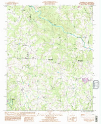
1993 Map of Fingerville East
USGS Topo · Published 1996About this map
Fingerville and Cooley Springs anchor the southern reaches of this landscape, where the Pacolet River and Buck Creek drain the rolling terrain of Spartanburg County. The map captures a rural network of community life defined by numerous local houses of worship, including Cedar Grove Ch, Alverson Grove Ch, and Gaffney Chapel. This 1993 revision, featuring updates in purple from aerial imagery, illustrates the enduring settlement patterns along the border of North Carolina and South Carolina.
Find a feature on this map
42 named features on this map. Tap any name to fly to it.
Don’t see what you’re looking for? This feature index may not catch every label — zoom into the map to look around manually.
Map Details
Editions of this 1993 Fingerville East Map
This is the sole edition of this map. No revisions or reprints were ever made.
Other maps of this area

1907 · Saluda
USGS Topo · 1:125,000

1953 · Charlotte
USGS Topo · 1:250,000

1954 · Charlotte
USGS Topo · 1:250,000

1955 · Knoxville
USGS Topo · 1:250,000

1957 · Knoxville
USGS Topo · 1:250,000

1959 · Lake Lure
USGS Topo · 1:62,500

1959 · Cowpens
USGS Topo · 1:62,500

1960 · Knoxville
USGS Topo · 1:250,000

1960 · Charlotte
USGS Topo · 1:250,000

1961 · Inman
USGS Topo · 1:62,500