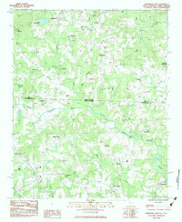
1983 Map of Fingerville West
USGS Topo · Published 1983About this map
North Pacolet River winds across the Piedmont landscape where the state lines of North Carolina and South Carolina meet. This 1983 survey captures a rural landscape defined by historic church-centered communities and small settlements like Little Africa and New Prospect. The area shows a transition from traditional farming towards modern infrastructure, evidenced by the presence of the Fairview Airport and the interstate corridor of I-55. Local history is anchored by numerous congregational landmarks such as Mill Creek Ch, Riverside Ch, and Smith Chapel, alongside family-named locales like McGinnis Crossroads and Hickory Grove. The topography is marked by modest elevations such as Little Mountain, while the drainage network including Marys Branch and Turkey Creek dictates the historical placement of roads and homesteads.
Find a feature on this map
36 named features on this map. Tap any name to fly to it.
Don’t see what you’re looking for? This feature index may not catch every label — zoom into the map to look around manually.
Map Details
Editions of this 1983 Fingerville West Map
This is the sole edition of this map. No revisions or reprints were ever made.
Other maps of this area

1907 · Saluda
USGS Topo · 1:125,000

1953 · Charlotte
USGS Topo · 1:250,000

1954 · Charlotte
USGS Topo · 1:250,000

1955 · Knoxville
USGS Topo · 1:250,000

1957 · Knoxville
USGS Topo · 1:250,000

1959 · Lake Lure
USGS Topo · 1:62,500

1959 · Cowpens
USGS Topo · 1:62,500

1960 · Knoxville
USGS Topo · 1:250,000

1960 · Charlotte
USGS Topo · 1:250,000

1961 · Inman
USGS Topo · 1:62,500