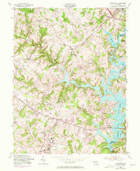
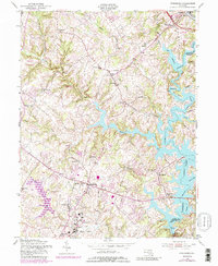
1953 Map of Finksburg
USGS Topo · Published 1971About this map
Springfield State Hospital anchors the southern landscape of this Carroll County survey, displaying a significant institutional footprint just north of Sykesville. The topography is dominated by the sprawling Liberty Lake, a reservoir created by the damming of the North Branch Patapsco River, which winds along the eastern boundary between Carroll and Baltimore counties. The 1953 culture revision, updated with 1971 aerial observations, shows the transition from rural crossroads like Gamber and Eldersburg toward a more modern suburban-residential pattern, particularly along Liberty Road. Traces of the region's agricultural and early industrial past remain visible through features like Glee Mill and the Western Maryland RR corridor near Finksburg. A network of small community centers, including Johnsville and Freedom, is documented alongside numerous country houses of worship such as Bethesda Ch and Harmony Grove Ch, providing a detailed look at mid-century Maryland settlement.
Find a feature on this map
41 named features on this map. Tap any name to fly to it.
Don’t see what you’re looking for? This feature index may not catch every label — zoom into the map to look around manually.
Map Details
Editions of this 1953 Finksburg Map
5 editions found
Other maps of this area

1892 · Ellicott
USGS Topo · 1:62,500

1893 · Frederick
USGS Topo · 1:125,000

1894 · Ellicott
USGS Topo · 1:62,500

1894 · Frederick
USGS Topo · 1:125,000

1905 · Westminster
USGS Topo · 1:62,500

1906 · Ellicott
USGS Topo · 1:62,500

1908 · Patapsco
USGS Topo · 1:125,000

1909 · Mount Airy
USGS Topo · 1:62,500

1911 · Taneytown
USGS Topo · 1:62,500

1942 · Gettysburg
USGS Topo · 1:125,000