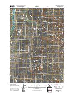
2011 Map of Finley Butte
USGS Topo · Published 2011About this map
Paulina Prairie and the emerging residential grid of La Pine define this landscape east of the Little Deschutes River in the early 21st century. The map documents a transition from open prairie and forest to a structured community, evidenced by the dense network of local roads such as Rosland Rd and Drake Rd. Local history is anchored by the Breese Cemetery and the uniquely named Improved Order of Redmen Cemetery located near the center of the quadrangle.
Find a feature on this map
51 named features on this map. Tap any name to fly to it.
Don’t see what you’re looking for? This feature index may not catch every label — zoom into the map to look around manually.
Map Details
Editions of this 2011 Finley Butte Map
This is the sole edition of this map. No revisions or reprints were ever made.
Other maps of this area

1930 · Maiden Peak
USGS Topo · 1:125,000

1931 · Newberry Crater
USGS Topo · 1:125,000

1934 · Maiden Peak
USGS Topo · 1:125,000

1935 · Newberry Crater
USGS Topo · 1:125,000

1955 · Crescent
USGS Topo · 1:250,000

1957 · Crescent
USGS Topo · 1:250,000

1958 · Crescent
USGS Topo · 1:250,000
1963 · Lava Cast Forest
USGS Topo · 1:24,000
1963 · Anns Butte
USGS Topo · 1:24,000

1963 · La Pine
USGS Topo · 1:24,000