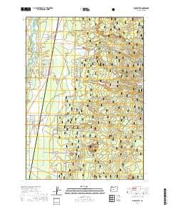
2020 Map of Finley Butte
USGS Topo · Published 2020About this map
La Pine and its surrounding high desert landscape are defined by volcanic geology and the sprawling reach of the Deschutes National Forest. The topography is dominated by the massive Newberry Volcano and its associated peaks, including Finley Butte and Abacus Buttes. Water is a precious commodity in this environment, represented by the meandering Little Deschutes River on the western edge and Paulina Cr, which cuts through the Paulina Prairie. For local historians, the presence of the Improved Order of Redmen Cem and Breese Cem provides specific points of interest regarding early 20th-century fraternal organizations and homesteading families. The map also reveals an extensive network of specialized routes, such as Peter Skene Ogden, alongside numerous snow trails like Newberry #121 (Snow), indicating the area's modern identity as a hub for year-round outdoor recreation.
Find a feature on this map
43 named features on this map. Tap any name to fly to it.
Don’t see what you’re looking for? This feature index may not catch every label — zoom into the map to look around manually.
Map Details
Editions of this 2020 Finley Butte Map
This is the sole edition of this map. No revisions or reprints were ever made.
Other maps of this area

1930 · Maiden Peak
USGS Topo · 1:125,000

1931 · Newberry Crater
USGS Topo · 1:125,000

1934 · Maiden Peak
USGS Topo · 1:125,000

1935 · Newberry Crater
USGS Topo · 1:125,000

1955 · Crescent
USGS Topo · 1:250,000

1957 · Crescent
USGS Topo · 1:250,000

1958 · Crescent
USGS Topo · 1:250,000
1963 · Lava Cast Forest
USGS Topo · 1:24,000
1963 · Anns Butte
USGS Topo · 1:24,000

1963 · La Pine
USGS Topo · 1:24,000