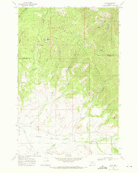
1968 Map of Finn
USGS Topo · Published 1971About this map
Helena National Forest terrain dominates this 1960s survey, where the peaks of Dalton Mountain and its Lookout Tower overlook a landscape of deep gulches and old mining prospects. The small settlement of Finn sits at the confluence of Finn Creek and Nevada Creek, serving as a focal point for the surrounding cattle country and timber lands. The map detail highlights the remnants of early 20th-century extraction, featuring the Wiggins Mine and various unnamed mines and prospects tucked into the drainages of McClellan Gulch and Bear Gulch. Traditional routes through the mountains are preserved here via the Helena (Pack) Trail and the Gould Helmville Trail, which cut across the border between Lewis and Clark and Powell counties. This documentation of water rights and access is further detailed through labels for Jefferson Creek, Washington Creek, and Slough Mill Creek.
Find a feature on this map
32 named features on this map. Tap any name to fly to it.
Don’t see what you’re looking for? This feature index may not catch every label — zoom into the map to look around manually.
Map Details
Editions of this 1968 Finn Map
3 editions found
Other maps of this area

1889 · Helena
USGS Topo · 1:250,000

1893 · Helena
USGS Topo · 1:250,000

1899 · Helena
USGS Topo · 1:250,000

1903 · Helena
USGS Topo · 1:250,000

1947 · Butte
USGS Topo · 1:250,000

1958 · Butte
USGS Topo · 1:250,000

1958 · Avon
USGS Topo · 1:62,500

1958 · Garrison
USGS Topo · 1:62,500

1960 · Butte
USGS Topo · 1:250,000

1962 · Butte
USGS Topo · 1:250,000