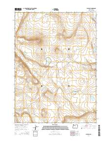
2014 Map of Fire Lake
USGS Topo · Published 2014About this map
Fire Lake sits at the heart of this high desert terrain in Lake County, where water resources define the sparse human footprint. The landscape is characterized by its intermittent lakes and specialized ranching infrastructure, featuring isolated catchments like Depaoli Lake and Aldc Waterhole. A notable industrial presence is found in the southwestern corner at the Diatomite Mine, reflecting the region's geological history. Primitive transportation routes like E Burma traverse the topography, which is shaped by the prominent Saunders Rim and Rocky Draw. This survey illustrates the vital importance of water management in the Oregon interior, where every Saunders Waterhole and S Dc Waterhole serves as a critical waypoint for land use and navigation across several township and range divisions.
Find a feature on this map
17 named features on this map. Tap any name to fly to it.
Don’t see what you’re looking for? This feature index may not catch every label — zoom into the map to look around manually.
Map Details
Editions of this 2014 Fire Lake Map
This is the sole edition of this map. No revisions or reprints were ever made.
Other maps of this area

1955 · Crescent
USGS Topo · 1:250,000

1955 · Klamath Falls
USGS Topo · 1:250,000

1957 · Crescent
USGS Topo · 1:250,000

1958 · Crescent
USGS Topo · 1:250,000

1958 · Klamath Falls
USGS Topo · 1:250,000

1970 · Crescent
USGS Topo · 1:250,000

1974 · Lake Abert
USGS Topo · 1:100,000
1984 · Poverty Basin South
USGS Topo · 1:24,000
1984 · Poverty Basin North
USGS Topo · 1:24,000

1984 · Horse Mtn
USGS Topo · 1:24,000