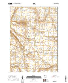
2020 Map of Fire Lake
USGS Topo · Published 2020About this map
Fire Lake and its surrounding desert basins characterize this high-desert landscape in Lake County. The presence of the Diatomite Mine in the southwest corner indicates the region's industrial connection to sedimentary mineral extraction, a common pursuit in these dry lakebeds. The terrain is defined by dramatic elevation changes, most notably along Saunders Rim, which overlooks several vital water sources including Saunders Waterhole and West Saunders Waterhole. These features, along with Depaoli Lake and the specifically named Sammys Horse Pen Waterhole, highlight the importance of water management for livestock and wildlife in this arid section of Oregon. The map detail follows the township and range lines, providing a clear look at the remote physical geography before modern land-use changes.
Find a feature on this map
13 named features on this map. Tap any name to fly to it.
Don’t see what you’re looking for? This feature index may not catch every label — zoom into the map to look around manually.
Map Details
Editions of this 2020 Fire Lake Map
This is the sole edition of this map. No revisions or reprints were ever made.
Other maps of this area

1955 · Crescent
USGS Topo · 1:250,000

1955 · Klamath Falls
USGS Topo · 1:250,000

1957 · Crescent
USGS Topo · 1:250,000

1958 · Crescent
USGS Topo · 1:250,000

1958 · Klamath Falls
USGS Topo · 1:250,000

1970 · Crescent
USGS Topo · 1:250,000

1974 · Lake Abert
USGS Topo · 1:100,000
1984 · Poverty Basin South
USGS Topo · 1:24,000
1984 · Poverty Basin North
USGS Topo · 1:24,000

1984 · Horse Mtn
USGS Topo · 1:24,000