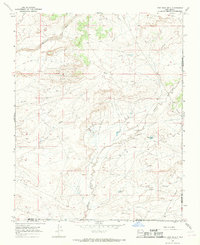
1966 Map of Fire Rock Well
USGS Topo · Published 1969About this map
Escavada Wash and Gallo Wash define the drainage patterns of this high-desert landscape, where human activity is largely centered on water management and resource extraction. The 1966 survey records a network of water-focused infrastructure, including Fire Rock Well, Marve Well, and the Oil Well Dam near Spillway Elev 6553. These features, alongside the Dike Pit Tank, illustrate the critical importance of water storage in this arid corner of the San Juan Basin.
Find a feature on this map
15 named features on this map. Tap any name to fly to it.
Don’t see what you’re looking for? This feature index may not catch every label — zoom into the map to look around manually.
Map Details
Editions of this 1966 Fire Rock Well Map
2 editions found
Other maps of this area

1883 · Mt. Taylor
USGS Topo · 1:250,000

1886 · Mt. Taylor
USGS Topo · 1:250,000

1889 · Largo
USGS Topo · 1:250,000

1892 · Mt. Taylor
USGS Topo · 1:250,000

1895 · Largo
USGS Topo · 1:250,000

1899 · Mt. Taylor
USGS Topo · 1:250,000

1954 · Aztec
USGS Topo · 1:250,000

1958 · Aztec
USGS Topo · 1:250,000

1958 · Albuquerque
USGS Topo · 1:250,000

1960 · Pueblo Alto Trading Post
USGS Topo · 1:24,000