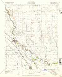
1946 Map of Firebaugh
USGS Topo · Published 1954About this map
The San Joaquin River meanders through the heart of the Central Valley in this mid-century survey, defining the industrial and agricultural character of the region. The map captures a critical period of hydraulic engineering, featuring the Mendota Dam and an extensive network of irrigation infrastructure including the Delta-Mendota Canal, Main Canal, and Outside Canal. These waterways, alongside the Fresno Slough and Lone Willow Slough, illustrate the intensive transformation of the landscape to support the burgeoning ranching economy seen at Helm Ranch and Mowry Ranch.
Find a feature on this map
55 named features on this map. Tap any name to fly to it.
Don’t see what you’re looking for? This feature index may not catch every label — zoom into the map to look around manually.
Map Details
Editions of this 1946 Firebaugh Map
2 editions found
Other maps of this area

1913 · Panoche
USGS Topo · 1:125,000

1916 · Berenda
USGS Topo · 1:31,680

1916 · Santa Rita Bridge
USGS Topo · 1:24,000

1918 · Bliss Ranch
USGS Topo · 1:31,680

1918 · Chowchilla
USGS Topo · 1:31,680

1918 · Berenda
USGS Topo · 1:31,680

1920 · Santa Rita Bridge
USGS Topo · 1:31,680

1920 · Bonita Ranch
USGS Topo · 1:31,680

1921 · Mendota
USGS Topo · 1:31,680

1921 · Bonita Ranch
USGS Topo · 1:31,680