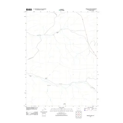
2012 Map of Firehole Basin
USGS Topo · Published 2012About this map
Firehole Basin dominates this portion of Sweetwater County, where the high desert landscape is defined by drainage systems and ranching corridors. The area is anchored by the Sage Creek Ranch, located along the southern drainage of Sage Cr. This watercourse, along with Spring Cr, dictates the placement of local infrastructure, including Sage Creek Rd and Ramsey Ranch Rd. The terrain is characterized by significant natural depressions and heights, from the western Johnson Draw and Faulkner Draw to the prominent rising profile of Sheep Mountain at the southern edge. Accessibility to this arid region is provided by the network of Flaming Gorge Rd and Little Firehole Rd, reflecting the long-standing routes used by local landowners and travelers through this Wyoming interior.
Find a feature on this map
12 named features on this map. Tap any name to fly to it.
Don’t see what you’re looking for? This feature index may not catch every label — zoom into the map to look around manually.
Map Details
Editions of this 2012 Firehole Basin Map
This is the sole edition of this map. No revisions or reprints were ever made.
Other maps of this area

1954 · Rock Springs
USGS Topo · 1:250,000

1957 · Currant Creek Ranch
USGS Topo · 1:62,500

1957 · Firehole Basin
USGS Topo · 1:62,500

1958 · Rock Springs
USGS Topo · 1:250,000

1962 · Rock Springs
USGS Topo · 1:250,000
1963 · Maxon Ranch
USGS Topo · 1:24,000

1966 · Firehole Basin
USGS Topo · 1:62,500

1966 · Currant Creek Ranch
USGS Topo · 1:62,500
1968 · Earnest Butte
USGS Topo · 1:24,000
1968 · Kappes Canyon
USGS Topo · 1:24,000