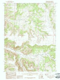
1987 Map of Firehole Basin
USGS Topo · Published 1987About this map
Firehole Basin dominates this 1980s terrain study, revealing a landscape defined by significant elevation changes and the infrastructure of the energy industry. A single Grave situated near the headwaters of Sage Creek offers a rare genealogical marker in an area otherwise characterized by its geological features and technical development. The map meticulously documents the network of 4wd tracks and a major Pipeline that traverse the high plateaus between Flattop Mountain and Sheep Mountain.
Find a feature on this map
17 named features on this map. Tap any name to fly to it.
Don’t see what you’re looking for? This feature index may not catch every label — zoom into the map to look around manually.
Map Details
Editions of this 1987 Firehole Basin Map
This is the sole edition of this map. No revisions or reprints were ever made.
Other maps of this area

1954 · Rock Springs
USGS Topo · 1:250,000

1957 · Currant Creek Ranch
USGS Topo · 1:62,500

1957 · Firehole Basin
USGS Topo · 1:62,500

1958 · Rock Springs
USGS Topo · 1:250,000

1962 · Rock Springs
USGS Topo · 1:250,000
1963 · Maxon Ranch
USGS Topo · 1:24,000

1966 · Firehole Basin
USGS Topo · 1:62,500

1966 · Currant Creek Ranch
USGS Topo · 1:62,500
1968 · Earnest Butte
USGS Topo · 1:24,000
1968 · Kappes Canyon
USGS Topo · 1:24,000