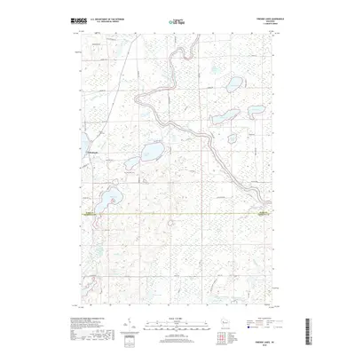
2018 Map of Fireside Lakes
USGS Topo · Published 2018About this map
Island Lake serves as a central point of settlement in this lake-studded landscape on the border of Rusk and Chippewa counties. The area is defined by its complex hydrology, where the Chippewa River winds past several major basins including Marsh Lake and Pulaski Lake. For genealogists and local historians, the map preserves the location of the Island Lake Cem and Mud Lake Cem, along with the appropriately named School Lake.
Find a feature on this map
69 named features on this map. Tap any name to fly to it.
Don’t see what you’re looking for? This feature index may not catch every label — zoom into the map to look around manually.
Map Details
Editions of this 2018 Fireside Lakes Map
This is the sole edition of this map. No revisions or reprints were ever made.
Other maps of this area

1948 · Weyerhauser
USGS Topo · 1:48,000

1948 · Ladysmith
USGS Topo · 1:48,000

1949 · Bloomer
USGS Topo · 1:62,500

1950 · Weyerhauser
USGS Topo · 1:48,000

1950 · Ladysmith
USGS Topo · 1:48,000

1951 · Bloomer
USGS Topo · 1:62,500

1951 · Cornell
USGS Topo · 1:62,500

1953 · Rice Lake
USGS Topo · 1:250,000

1959 · Rice Lake
USGS Topo · 1:250,000
1971 · Thornapple
USGS Topo · 1:24,000