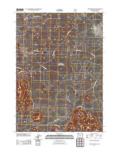
2011 Map of Firestone Butte
USGS Topo · Published 2011About this map
Firestone Butte and the surrounding volcanic terrain of Deschutes County dominate this modern US Topo sheet, illustrating a landscape defined by forest management and geological landmarks. This high-desert region is characterized by a dense network of National Forest Development Roads, such as Nat For Dev Rd 2310 and Nat For Dev Rd 650, which provide access to the timber and recreation areas managed by the U.S. Forest Service. The presence of features like Quartz Mtn Rd leading toward Quartz Mountain and the specialized Lava Bed Rd reflect the unique geological composition of this Oregon interior. Grounded in 2009 NAIP imagery and GNIS data, the map reveals a topographic pattern where relief is centered on distinct volcanic vents like East Butte and Rogers Butte, connected by arterial routes such as Mahogany Butte Rd.
Find a feature on this map
18 named features on this map. Tap any name to fly to it.
Don’t see what you’re looking for? This feature index may not catch every label — zoom into the map to look around manually.
Map Details
Editions of this 2011 Firestone Butte Map
This is the sole edition of this map. No revisions or reprints were ever made.
Other maps of this area

1931 · Newberry Crater
USGS Topo · 1:125,000

1935 · Newberry Crater
USGS Topo · 1:125,000

1955 · Crescent
USGS Topo · 1:250,000

1957 · Crescent
USGS Topo · 1:250,000

1958 · Crescent
USGS Topo · 1:250,000

1966 · Millican SE
USGS Topo · 1:24,000
1967 · Evans Well
USGS Topo · 1:24,000
1967 · Pine Mountain
USGS Topo · 1:24,000

1970 · Crescent
USGS Topo · 1:250,000

1981 · Fox Butte
USGS Topo · 1:24,000