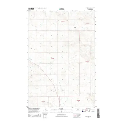
2014 Map of First Creek
USGS Topo · Published 2014About this map
Peterson Draw and the surrounding drainage basins of Custer County dominate this 2014 survey. The landscape is defined by a dendritic network of seasonal and perennial waterways, including the prominent Pumpkin Cr, which snakes through the western half of the quadrangle. Other tributaries such as Johnson Cr and First Cr illustrate the complex hydrography of this Montana prairie region. Human presence is concentrated along Mt-59, the primary north-south artery that provides passage through this expansive section of the Public Land Survey System. The map meticulously documents the legal boundaries across Townships 4, 5, and 6 North, providing a clear view of the territorial divisions and road network at the start of the second decade of the 21st century.
Find a feature on this map
15 named features on this map. Tap any name to fly to it.
Don’t see what you’re looking for? This feature index may not catch every label — zoom into the map to look around manually.
Map Details
Editions of this 2014 First Creek Map
This is the sole edition of this map. No revisions or reprints were ever made.
Other maps of this area

1953 · Miles City
USGS Topo · 1:250,000

1957 · Miles City
USGS Topo · 1:250,000

1958 · Miles City
USGS Topo · 1:250,000

1969 · Horse Creek
USGS Topo · 1:24,000

1969 · Haines Springs
USGS Topo · 1:24,000

1969 · First Creek
USGS Topo · 1:24,000

1969 · Loaf of Bread Butte
USGS Topo · 1:24,000

1969 · Beebe SW
USGS Topo · 1:24,000

1969 · Miles City Creek
USGS Topo · 1:24,000
1969 · Beebe
USGS Topo · 1:24,000