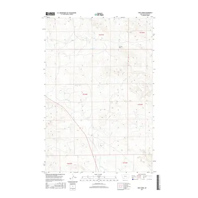
2017 Map of First Creek
USGS Topo · Published 2017About this map
Pumpkin Cr and its various tributaries define the drainage patterns across this part of Custer County, Montana. This 2017 survey illustrates the complex topography of the high plains, where the land is carved by seasonal watercourses like Second Cr, Third Cr, and Jack Cr. The map is characterized by a sparse road network, with Rd 538 serving as one of the few primary routes through the landscape. Landmarks such as Peterson Draw provide localized orientation in an area otherwise dominated by the natural branching of Johnson Cr and First Creek. The map provides a look at the modern-day configuration of Public Land Survey System townships, including T6N R49E and T5N R50E, which organize the vast open spaces of the eastern Montana rangeland.
Find a feature on this map
15 named features on this map. Tap any name to fly to it.
Don’t see what you’re looking for? This feature index may not catch every label — zoom into the map to look around manually.
Map Details
Editions of this 2017 First Creek Map
This is the sole edition of this map. No revisions or reprints were ever made.
Other maps of this area

1953 · Miles City
USGS Topo · 1:250,000

1957 · Miles City
USGS Topo · 1:250,000

1958 · Miles City
USGS Topo · 1:250,000

1969 · Horse Creek
USGS Topo · 1:24,000

1969 · Haines Springs
USGS Topo · 1:24,000

1969 · First Creek
USGS Topo · 1:24,000

1969 · Loaf of Bread Butte
USGS Topo · 1:24,000

1969 · Beebe SW
USGS Topo · 1:24,000

1969 · Miles City Creek
USGS Topo · 1:24,000
1969 · Beebe
USGS Topo · 1:24,000