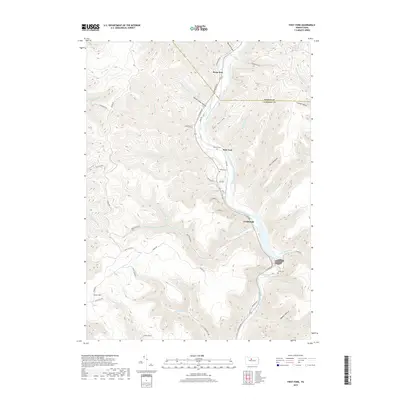
2019 Map of First Fork
USGS Topo · Published 2019About this map
First Fork Sinnemahoning Creek carves a deep valley through the high plateaus of Potter County and Cameron County, serving as the primary corridor for human movement and settlement in this part of north-central Pennsylvania. The small riverside communities of First Fork and Lushbaugh occupy the narrow floor of the valley, connected by 1st Fork Rd. The surrounding terrain is defined by a dense network of steep hollows and ridges, such as Upper Logue Hollow and Owl Hollow, where numerous tributaries like Berge Run and Miley Run drain into the main stem. Evidence of the area's rural history is found in several family and community landmarks, including Gilmore Cem near the fork and Smith Cem further downstream. Higher elevations like Grove Hill remain largely defined by forest access routes such as Lick Island Forest Rd and the Ridge Trl.
Find a feature on this map
60 named features on this map. Tap any name to fly to it.
Don’t see what you’re looking for? This feature index may not catch every label — zoom into the map to look around manually.
Map Details
Editions of this 2019 First Fork Map
This is the sole edition of this map. No revisions or reprints were ever made.
Other maps of this area

1945 · Driftwood
USGS Topo · 1:48,000

1945 · First Fork
USGS Topo · 1:24,000

1945 · Sinnemahoning
USGS Topo · 1:24,000

1945 · Driftwood
USGS Topo · 1:24,000

1945 · Cameron
USGS Topo · 1:24,000

1946 · Renovo West
USGS Topo · 1:62,500

1946 · Hammersley Fork
USGS Topo · 1:24,000

1946 · Keating
USGS Topo · 1:24,000

1947 · Cameron
USGS Topo · 1:24,000

1947 · First Fork
USGS Topo · 1:24,000
Featured Places
- Wharton Township, PA
- First Fork, Grove Township
- Lushbaugh, Grove Township
- Gibson Township, PA
- Lumber Township, PA