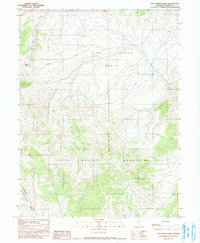
1990 Map of Fish Creek Basin
USGS Topo · Published 1990About this map
Fish Creek Basin defines the central topography of this Nevada landscape, framed by the heights of the Fish Creek Mountains to the south. The area is characterized by high-desert hydrology, with numerous Springs and the drainage of Fish Creek and Cottonwood Creek providing the only water in an otherwise arid environment. Evidence of mineral exploration and land use is sparse but present, notably at Daisy Pass where the map labels several Prospects and a Gravel Pit near the Daisy trail. These small-scale excavations suggest the region's history of prospecting during the late 20th century. The presence of a Tank and various unimproved roads indicates the area's continued use for livestock or local resource extraction, even as large portions remain undeveloped.
Find a feature on this map
14 named features on this map. Tap any name to fly to it.
Don’t see what you’re looking for? This feature index may not catch every label — zoom into the map to look around manually.
Map Details
Editions of this 1990 Fish Creek Basin Map
This is the sole edition of this map. No revisions or reprints were ever made.
Other maps of this area

1932 · Sonoma Range
USGS Topo · 1:250,000

1939 · Sonoma Range
USGS Topo · 1:250,000

1955 · Winnemucca
USGS Topo · 1:250,000

1958 · Winnemucca
USGS Topo · 1:250,000

1961 · McCoy
USGS Topo · 1:62,500

1961 · The Cedars
USGS Topo · 1:62,500

1961 · Mt. Moses
USGS Topo · 1:62,500

1962 · Winnemucca
USGS Topo · 1:250,000

1962 · Buffalo Springs
USGS Topo · 1:62,500

1982 · Fish Creek Mts
USGS Topo · 1:100,000