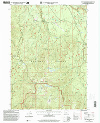
1997 Map of Fish Creek Desert
USGS Topo · Published 1999About this map
Umpqua National Forest defines the high timberland of Douglas County in the late 1990s, where the landscape is marked by the complex drainage of the Clearwater River and Fish Creek. The topography is dominated by prominent ridges and peaks such as Rhododendron Ridge and Mud Lake Mountain, while the hydrology is controlled by infrastructure like the Fish Creek Diversion Dam and a Gaging Station.
Find a feature on this map
45 named features on this map. Tap any name to fly to it.
Don’t see what you’re looking for? This feature index may not catch every label — zoom into the map to look around manually.
Map Details
Editions of this 1997 Fish Creek Desert Map
This is the sole edition of this map. No revisions or reprints were ever made.
Other maps of this area

1917 · Diamond Lake
USGS Topo · 1:125,000

1955 · Quartz Mtn
USGS Topo · 1:62,500

1955 · Illahee Rock
USGS Topo · 1:62,500

1956 · Toketee Falls
USGS Topo · 1:62,500

1956 · Garwood Butte
USGS Topo · 1:62,500

1958 · Roseburg
USGS Topo · 1:250,000

1959 · Roseburg
USGS Topo · 1:250,000

1978 · Diamond Lake
USGS Topo · 1:100,000
1985 · Garwood Butte
USGS Topo · 1:24,000
1985 · Hamaker Butte
USGS Topo · 1:24,000