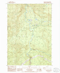
1985 Map of Fish Creek Mountain
USGS Topo · Published 1985About this map
The Clackamas River carves a deep valley through this portion of the Mt Hood National Forest, serving as the primary corridor for forestry and recreation in the mid-1980s. The settlement of Ripplebrook stands as a focal point for activity, hosting the Ripplebrook Ranger Station, a Heliport, and the nearby Ripplebrook Campground. Further north, the Timber Lake Job Corps Center is located near Timber Lake, highlighting the area's role in public works and conservation during this era.
Find a feature on this map
61 named features on this map. Tap any name to fly to it.
Don’t see what you’re looking for? This feature index may not catch every label — zoom into the map to look around manually.
Map Details
Editions of this 1985 Fish Creek Mountain Map
This is the sole edition of this map. No revisions or reprints were ever made.
Other maps of this area

1916 · Estacada
USGS Topo · 1:125,000

1924 · Mount Hood
USGS Topo · 1:125,000

1927 · Mount Hood
USGS Topo · 1:125,000

1927 · Mt. Jefferson
USGS Topo · 1:125,000

1929 · Mill City
USGS Topo · 1:125,000

1930 · Mt. Jefferson
USGS Topo · 1:125,000

1948 · Vancouver
USGS Topo · 1:250,000

1950 · Vancouver
USGS Topo · 1:250,000

1950 · Vancouver
USGS Topo · 1:250,000

1953 · Salem
USGS Topo · 1:250,000