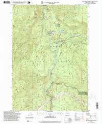
1997 Map of Fish Creek Mountain
USGS Topo · Published 1999About this map
The Clackamas River carves through the central corridor of this Oregon landscape, serving as the primary geographic axis for forest management and recreation during the late 1990s. This territory within the Mount Hood National Forest shows a complex network of resource extraction and administrative infrastructure, including the Clackamas Ranger Station and the Timber Lake Job Corps Center near Ripplebrook. The map captures a transition in forest use, where active industrial sites like the Umpqua Quarry, Boneyard Quarry, and Mistletoe Gravel Pit exist alongside established recreational and natural landmarks. Historically significant points such as Indian Henry and Austin Hot Springs are documented along the river's edge, while high-elevation features like Fish Creek Mountain and Bull of the Woods define the surrounding terrain. The presence of a Heliport and multiple communication towers indicates the logistical importance of this area for regional fire and forest monitoring.
Find a feature on this map
52 named features on this map. Tap any name to fly to it.
Don’t see what you’re looking for? This feature index may not catch every label — zoom into the map to look around manually.
Map Details
Editions of this 1997 Fish Creek Mountain Map
This is the sole edition of this map. No revisions or reprints were ever made.
Other maps of this area

1916 · Estacada
USGS Topo · 1:125,000

1924 · Mount Hood
USGS Topo · 1:125,000

1927 · Mount Hood
USGS Topo · 1:125,000

1927 · Mt. Jefferson
USGS Topo · 1:125,000

1929 · Mill City
USGS Topo · 1:125,000

1930 · Mt. Jefferson
USGS Topo · 1:125,000

1948 · Vancouver
USGS Topo · 1:250,000

1950 · Vancouver
USGS Topo · 1:250,000

1950 · Vancouver
USGS Topo · 1:250,000

1953 · Salem
USGS Topo · 1:250,000