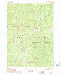
1989 Map of Fish Mountain
USGS Topo · Published 1990About this map
The Rogue-Umpqua Divide runs through this high-elevation terrain, marking the boundary between the Umpqua National Forest and Rogue River National Forest. Surveyed in the late 1980s, the landscape is defined by its network of pack trails and remote outpost sites like the Cripple Camp Shelter and Hummingbird Campsite. Geologic features are prominent, including the distinctive Rabbit Ears spires and the sharp verticality of Highrock Mountain and Castle Rock. Evidence of resource extraction is present in the form of a Prospect Adit and an Open Pit Mine located near Windy Gap. The area’s hydrological character is established by numerous high-country lakes such as Fish Lake, Toad Lake, and the Snow Lakes, which feed the many creeks branching from the central divide.
Find a feature on this map
59 named features on this map. Tap any name to fly to it.
Don’t see what you’re looking for? This feature index may not catch every label — zoom into the map to look around manually.
Map Details
Editions of this 1989 Fish Mountain Map
This is the sole edition of this map. No revisions or reprints were ever made.
Other maps of this area

1891 · Ashland
USGS Topo · 1:250,000

1893 · Ashland
USGS Topo · 1:250,000

1897 · Ashland
USGS Topo · 1:250,000

1917 · Diamond Lake
USGS Topo · 1:125,000

1944 · Abbott Butte
USGS Topo · 1:62,500

1947 · Abbott Butte
USGS Topo · 1:62,500

1955 · Quartz Mtn
USGS Topo · 1:62,500

1955 · Medford
USGS Topo · 1:250,000

1956 · Garwood Butte
USGS Topo · 1:62,500

1956 · Prospect
USGS Topo · 1:62,500