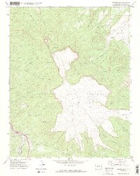
1971 Map of Fishers Peak
USGS Topo · Published 1974About this map
The massive Beaubien and Miranda and Maxwell Land Grant boundaries dominate this high-desert landscape, highlighting the complex history of territorial land tenure in southern Colorado. Centered on the flat-topped volcanic landmark of Fishers Peak, the map reveals a rugged terrain carved by drainage systems like Capulin Creek and San Miguel Creek. In the lower elevations, industrial and agricultural footprints appear along the Atchison Topeka and Santa Fe railroad line and the Raton Creek valley. Evidence of early resource extraction is found at the Grave Mines and various gas wells, while the presence of a Corral and named springs such as Cassiddays Spring suggest a long history of ranching on the Mesa. Small pockets of settlement like San Miguel represent the sparse population centers that persisted in this high-altitude environment during the early 1970s.
Find a feature on this map
46 named features on this map. Tap any name to fly to it.
Don’t see what you’re looking for? This feature index may not catch every label — zoom into the map to look around manually.
Map Details
Editions of this 1971 Fishers Peak Map
2 editions found
Other maps of this area

1891 · Spanish Peaks
USGS Topo · 1:125,000

1892 · Elmoro
USGS Topo · 1:125,000

1893 · Spanish Peaks
USGS Topo · 1:125,000

1893 · Elmoro
USGS Topo · 1:125,000

1895 · Spanish Peaks
USGS Topo · 1:125,000

1897 · Elmoro
USGS Topo · 1:125,000

1897 · Spanish Peaks
USGS Topo · 1:125,000

1900 · Spanish Peaks
USGS Topo · 1:125,000

1912 · Raton
USGS Topo · 1:62,500

1914 · Raton
USGS Topo · 1:62,500