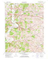
1982 Map of Fisherville
USGS Topo · Published 1982This historical map portrays the area of Fisherville in 1982, primarily covering Jefferson County as well as portions of Shelby County and Spencer County. Featuring a scale of 1:24000, this map provides a highly detailed snapshot of the terrain, roads, buildings, counties, and historical landmarks in the Fisherville region at the time. Published in 1982, it is one of 3 known editions of this map due to revisions or reprints.
Find a feature on this map
38 named features on this map. Tap any name to fly to it.
Don’t see what you’re looking for? This feature index may not catch every label — zoom into the map to look around manually.
Map Details
Editions of this 1982 Fisherville Map
3 editions found
Historical Maps of Wilsonville Through Time
23 maps found

1909 Kosmosdale
Jefferson County, KY

1912 Kosmosdale
Jefferson County, KY

1950 Kosmosdale
Jefferson County, KY

1951 Fisherville
Jefferson County, KY

1951 Louisville East
Jefferson County, KY

1951 Valley Station
Jefferson County, KY

1953 Madison East
Jefferson County, KY

1955 Louisville East
Jefferson County, KY

1955 Louisville West
Jefferson County, KY

1955 Valley Station
Jefferson County, KY

1960 Fisherville
Jefferson County, KY

1960 Louisville East
Jefferson County, KY

1960 Louisville West
Jefferson County, KY

1960 Valley Station
Jefferson County, KY

1965 Louisville East
Jefferson County, KY

1965 Louisville West
Jefferson County, KY

1981 Kosmosdale
Jefferson County, KY

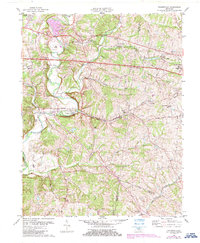
1982 Fisherville
Jefferson County, KY

1982 Louisville East
Jefferson County, KY

1982 Valley Station
Jefferson County, KY

1983 Louisville West
Jefferson County, KY

1993 Valley Station
Jefferson County, KY

1998 Louisville West
Jefferson County, KY