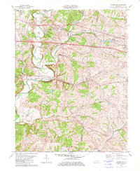
1982 Map of Fisherville
USGS Topo · Published 1982About this map
Fisherville and its surrounding communities sit along the winding course of Floyds Fork in eastern Jefferson County. This landscape is defined by the intersection of traditional crossroads settlements and significant transportation corridors, where the Louisville and Nashville and Southern Railway lines cut through the terrain. The presence of the Job Corps Center at Lincoln Ridge and the Sewerage Disposal facility near Eastwood reflects the mid-to-late 20th-century institutional and infrastructure developments in this area. To the south, the topography becomes increasingly broken as drainage from Plum Creek and Cane Run carves into the upland, leaving small farming clusters like Wilsonville and Clark connected by historic routes such as Old Taylorsville Road and Clarks Station Road. This map provides a detailed view of the rural-suburban interface before more recent residential expansion altered the character of these named Kentucky locales.
Find a feature on this map
38 named features on this map. Tap any name to fly to it.
Don’t see what you’re looking for? This feature index may not catch every label — zoom into the map to look around manually.
Map Details
Editions of this 1982 Fisherville Map
3 editions found
Other maps of this area

1905 · Prospect
USGS Topo · 1:62,500

1907 · Louisville
USGS Topo · 1:62,500

1912 · Prospect
USGS Topo · 1:62,500

1929 · Taylorsville
USGS Topo · 1:62,500

1932 · La Grange
USGS Topo · 1:62,500

1951 · Anchorage
USGS Topo · 1:24,000

1951 · Crestwood
USGS Topo · 1:24,000

1951 · Jeffersontown
USGS Topo · 1:24,000

1951 · Fisherville
USGS Topo · 1:24,000

1951 · Waterford
USGS Topo · 1:24,000