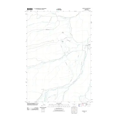
2011 Map of Fishtail
USGS Topo · Published 2011About this map
Fishtail serves as the primary hub in this Stillwater County landscape, where the Fishtail Post Office sits near the confluence of local irrigation and natural waterways. The area is defined by an intricate network of man-made water systems, including the Magee Ditch, Nels Thomas Ditch, and Dempster Ditch, which redirect the flow of West Rosebud Creek and Fishtail Creek to support the surrounding valley.
Find a feature on this map
36 named features on this map. Tap any name to fly to it.
Don’t see what you’re looking for? This feature index may not catch every label — zoom into the map to look around manually.
Map Details
Editions of this 2011 Fishtail Map
This is the sole edition of this map. No revisions or reprints were ever made.
Other maps of this area

1891 · Big Timber
USGS Topo · 1:125,000

1892 · Stillwater
USGS Topo · 1:125,000

1893 · Big Timber
USGS Topo · 1:125,000

1898 · Granite Mountain District
USGS Topo · 1:125,000

1932 · Red Lodge No 2
USGS Topo · 1:48,000

1932 · Nye No 1
USGS Topo · 1:48,000

1954 · Billings
USGS Topo · 1:250,000

1955 · Sandborn Creek
USGS Topo · 1:24,000

1955 · Absarokee
USGS Topo · 1:24,000
1955 · Cow Face Hill
USGS Topo · 1:24,000