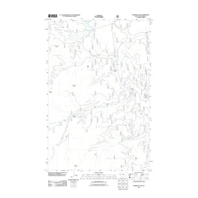
2011 Map of Fishtrap Lake
USGS Topo · Published 2011About this map
Upper Fishtrap Lake and Fishtrap Lake sit at the northern edge of this high-elevation mountain terrain in Sanders County. The landscape is defined by a dense network of drainages and named peaks, showing the 2011 status of National Forest roads and recreational infrastructure such as the Fishtrap Campground. Significant watercourses like the West Fork Fishtrap Creek and Beatrice Creek cut through deep valleys between prominent landmarks including Lone Tree Peak, Benson Peak, and Marmot Peak. The map provides a detailed view of the remote topography through features like Shorthorn Gulch and Lulu Gulch, documenting the specific access points and elevations that define this portion of the Montana wilderness. These details offer a clear record of the area's geography and forest management routes in the early twenty-first century.
Find a feature on this map
23 named features on this map. Tap any name to fly to it.
Don’t see what you’re looking for? This feature index may not catch every label — zoom into the map to look around manually.
Map Details
Editions of this 2011 Fishtrap Lake Map
This is the sole edition of this map. No revisions or reprints were ever made.
Other maps of this area

1937 · Thompson Falls
USGS Topo · 1:125,000

1937 · Thompson Falls
USGS Topo · 1:62,500

1956 · Wallace
USGS Topo · 1:250,000

1957 · Thompson Falls
USGS Topo · 1:62,500

1960 · Wallace
USGS Topo · 1:250,000

1964 · Calico Creek
USGS Topo · 1:24,000
1964 · Priscilla Peak
USGS Topo · 1:24,000

1966 · Vermilion Peak
USGS Topo · 1:24,000
1966 · Bend
USGS Topo · 1:24,000
1966 · Miller Lake
USGS Topo · 1:24,000