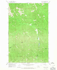
1966 Map of Miller Lake
USGS Topo · Published 1971About this map
Kootenai National Forest and Kaniksu National Forest dominate this mid-1960s survey of the mountain divide between Lincoln and Sanders counties. The landscape is defined by its drainage systems and high peaks, with Miller Lake and Sylvan Lake serving as focal points in the eastern section along East Fisher Creek. The ruggedness of the terrain is reflected in the network of historic routes, specifically the Himes Pack Trail and Blacktail Trail, which provided access through high-elevation gaps like Himes Pass and Willow Creek Pass. To the south, the terrain drops toward the Vermilion River, where narrow gulches such as Moose Gulch and Little Joe Gulch drain the slopes of Moose Peak. This map illustrates the intersection of two major national forests in a region shaped by timber management and remote wilderness access before modern road developments became widespread.
Find a feature on this map
29 named features on this map. Tap any name to fly to it.
Don’t see what you’re looking for? This feature index may not catch every label — zoom into the map to look around manually.
Map Details
Editions of this 1966 Miller Lake Map
2 editions found
Other maps of this area

1920 · Jennings
USGS Topo · 1:125,000

1935 · Thompson Lakes
USGS Topo · 1:96,000

1937 · Thompson Falls
USGS Topo · 1:125,000

1942 · Thompson Lakes
USGS Topo · 1:125,000

1956 · Wallace
USGS Topo · 1:250,000

1957 · Kalispell
USGS Topo · 1:250,000

1960 · Kalispell
USGS Topo · 1:250,000

1960 · Wallace
USGS Topo · 1:250,000

1961 · Kalispell
USGS Topo · 1:250,000

1966 · Vermilion Peak
USGS Topo · 1:24,000