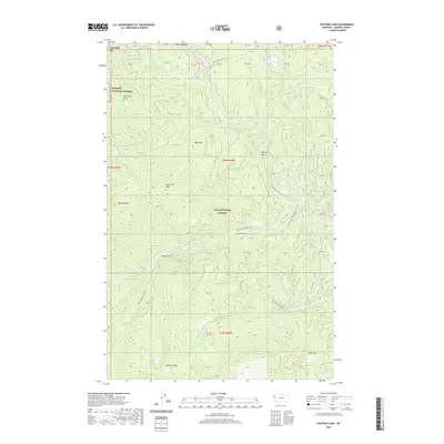
2020 Map of Fishtrap Lake
USGS Topo · Published 2020About this map
Kaniksu National Forest and Lolo National Forest converge in this high-altitude landscape within Sanders County. The terrain is defined by a series of prominent summits, including Marmot Peak, Benson Peak, and Lone Tree Peak, which rise above the complex drainages of the Fishtrap Cr system. To the north, Upper Fishtrap Lake serves as a primary water feature, fed by the Cooler Cr. This area is heavily managed for forest development, as evidenced by a network of specialized access routes such as Nat For Dev Rd Rd 7593 and Nat For Dev Rd Rd 516. The mapping reflects a rugged interior where drainages like Beartrap Fork and W Fork Fishtrap Cr create a labyrinth of steep draws, such as Lulu Gulch and Shorthorn Gulch, illustrating the remote and specialized nature of this timber and conservation land.
Find a feature on this map
49 named features on this map. Tap any name to fly to it.
Don’t see what you’re looking for? This feature index may not catch every label — zoom into the map to look around manually.
Map Details
Editions of this 2020 Fishtrap Lake Map
This is the sole edition of this map. No revisions or reprints were ever made.
Other maps of this area

1937 · Thompson Falls
USGS Topo · 1:125,000

1937 · Thompson Falls
USGS Topo · 1:62,500

1956 · Wallace
USGS Topo · 1:250,000

1957 · Thompson Falls
USGS Topo · 1:62,500

1960 · Wallace
USGS Topo · 1:250,000

1964 · Calico Creek
USGS Topo · 1:24,000
1964 · Priscilla Peak
USGS Topo · 1:24,000

1966 · Vermilion Peak
USGS Topo · 1:24,000
1966 · Bend
USGS Topo · 1:24,000
1966 · Miller Lake
USGS Topo · 1:24,000