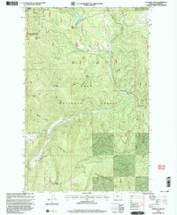
1999 Map of Fishtrap Lake
USGS Topo · Published 2003About this map
The Cabinet Mountains dominate this high-country survey of the Sanders County wilderness, where the borders of the Lolo National Forest and the Kaniksu National Forest converge. This 1990s revision reveals a landscape defined by dramatic drainage systems, centered on the flow of Fishtrap Creek and its major tributaries like the West Fork Fishtrap Creek and Bear-trap Fork. The map provides a detailed view of the remote alpine basins that feed these waters, including Fishtrap Lake, Upper Fishtrap Lake, and Stony Lake. Several named summits provide topographic orientation for the region, such as Wee Peak, Lone Tree Peak, and Marmot Peak. A Helispot near the latter indicates the modern logistical management of these protected forest lands, while trails like Whiteface trace the ridgelines and gulches.
Find a feature on this map
34 named features on this map. Tap any name to fly to it.
Don’t see what you’re looking for? This feature index may not catch every label — zoom into the map to look around manually.
Map Details
Editions of this 1999 Fishtrap Lake Map
This is the sole edition of this map. No revisions or reprints were ever made.
Other maps of this area

1937 · Thompson Falls
USGS Topo · 1:125,000

1937 · Thompson Falls
USGS Topo · 1:62,500

1956 · Wallace
USGS Topo · 1:250,000

1957 · Thompson Falls
USGS Topo · 1:62,500

1960 · Wallace
USGS Topo · 1:250,000

1964 · Calico Creek
USGS Topo · 1:24,000
1964 · Priscilla Peak
USGS Topo · 1:24,000

1966 · Vermilion Peak
USGS Topo · 1:24,000
1966 · Bend
USGS Topo · 1:24,000
1966 · Miller Lake
USGS Topo · 1:24,000