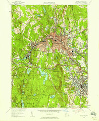
1954 Map of Fitchburg
USGS Topo · Published 1958About this map
Fitchburg and Leominster dominate this Worcester County landscape in the mid-1950s, revealing an industrial and institutional core shaped by the Whitman River and Nashua River valleys. The urban centers are densely packed with landmarks like the Fitchburg State Teachers College and Burbank Hospital, while the surrounding terrain is defined by steep heights such as Rollstone Hill and North Monoosnoc Hill. This era captures the rail-dependent infrastructure of the region, featuring junctions of the Boston and Maine RR and the New York New Haven and Hartford RR.
Find a feature on this map
82 named features on this map. Tap any name to fly to it.
Don’t see what you’re looking for? This feature index may not catch every label — zoom into the map to look around manually.
Map Details
Editions of this 1954 Fitchburg Map
3 editions found
Other maps of this area

1885 · Worcester
USGS Topo · 1:62,500

1886 · Worcester
USGS Topo · 1:62,500

1887 · Marlboro
USGS Topo · 1:62,500

1887 · Fitchburg
USGS Topo · 1:62,500

1889 · Marlboro
USGS Topo · 1:62,500

1889 · Fitchburg
USGS Topo · 1:62,500

1892 · Worcester
USGS Topo · 1:62,500

1893 · Fitchburg
USGS Topo · 1:62,500

1893 · Groton
USGS Topo · 1:62,500

1896 · Marlboro
USGS Topo · 1:62,500