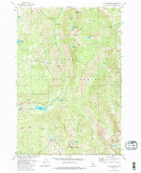
1973 Map of Fitsum Summit
USGS Topo · Published 1986About this map
Payette National Forest dominates this 1973 topographical study, revealing a complex drainage system where the Lake Fork Payette River branches into numerous forks. The landscape is punctuated by high-elevation landmarks such as Sawtooth Peak and Snowslide Peak, while the lower elevations show evidence of early utility and forestry infrastructure. The Lake Fork Forest Service Station and a Footbridge represent the active management of these lands, while the presence of an Old Powerplant and a Gaging Station near Fall Creek indicates historical water resource utilization. High-country lakes like Blackwell Lake and Squaw Lake are accessible via established routes such as the Black Lee Trail. Researchers will note the specialized land use indicated by the Boulder Driveway and a lonely Prospect located near the river's north fork, reflecting the era's balance between recreation and resource extraction.
Find a feature on this map
47 named features on this map. Tap any name to fly to it.
Don’t see what you’re looking for? This feature index may not catch every label — zoom into the map to look around manually.
Map Details
Editions of this 1973 Fitsum Summit Map
4 editions found
Other maps of this area

1911 · Meadows
USGS Topo · 1:125,000

1938 · Riggins
USGS Topo · 1:96,000

1945 · Riggins
USGS Topo · 1:125,000

1955 · Baker
USGS Topo · 1:250,000

1955 · Grangeville
USGS Topo · 1:250,000

1956 · Elk City
USGS Topo · 1:250,000

1957 · Challis
USGS Topo · 1:250,000

1959 · Baker
USGS Topo · 1:250,000

1959 · Grangeville
USGS Topo · 1:250,000

1960 · Elk City
USGS Topo · 1:250,000