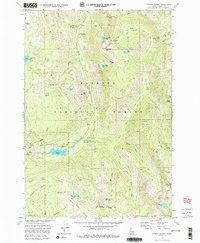
1973 Map of Fitsum Summit
USGS Topo · Published 1986About this map
Payette National Forest dominates this mountain landscape, defined by a network of drainage systems and high peaks in central Idaho. The map reveals a rugged backcountry where the Lake Fork Forest Service Station and Black Lee Campground serve as the primary human outposts. An interesting piece of local utility history is noted at the Old Powerplant near the Gaging Station, indicating early efforts to harness the water power of the local forks.
Find a feature on this map
48 named features on this map. Tap any name to fly to it.
Don’t see what you’re looking for? This feature index may not catch every label — zoom into the map to look around manually.
Map Details
Editions of this 1973 Fitsum Summit Map
4 editions found
Other maps of this area

1911 · Meadows
USGS Topo · 1:125,000

1938 · Riggins
USGS Topo · 1:96,000

1945 · Riggins
USGS Topo · 1:125,000

1955 · Baker
USGS Topo · 1:250,000

1955 · Grangeville
USGS Topo · 1:250,000

1956 · Elk City
USGS Topo · 1:250,000

1957 · Challis
USGS Topo · 1:250,000

1959 · Baker
USGS Topo · 1:250,000

1959 · Grangeville
USGS Topo · 1:250,000

1960 · Elk City
USGS Topo · 1:250,000