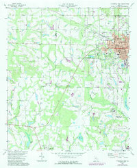
1973 Map of Fitzgerald West
USGS Topo · Published 1987About this map
The street grid of Fitzgerald anchors the eastern edge of this South Georgia landscape, where the CSX rail line facilitates the local economy. Established as a colony for Civil War veterans, the town's unique history is reflected in its structured layout, including Blue and Gray Park and several local institutions like Dorminy Memorial Hospital and the Fitzgerald Municipal Airport. Moving west across the Irwin and Ben Hill county line, the terrain transitions into a patchwork of timber and agriculture drained by Willacoochee Creek and Courthouse Branch. Scattered rural settlements like Mystic and Westwood are defined by their community hubs, including Arbor Church, New Prospect Church, and Friendship Church. The map also details early educational sites such as the Ben Hill-Irwin Vocational School, documenting the region's focus on technical training and industry in the late 20th century.
Find a feature on this map
54 named features on this map. Tap any name to fly to it.
Don’t see what you’re looking for? This feature index may not catch every label — zoom into the map to look around manually.
Map Details
Editions of this 1973 Fitzgerald West Map
2 editions found
Other maps of this area

1953 · Waycross
USGS Topo · 1:250,000

1958 · Waycross
USGS Topo · 1:250,000

1972 · Fitzgerald East
USGS Topo · 1:24,000

1972 · Ocilla East
USGS Topo · 1:24,000

1972 · Queensland
USGS Topo · 1:24,000

1973 · Ocilla West
USGS Topo · 1:24,000

1973 · Waterloo
USGS Topo · 1:24,000

1973 · Irwinville
USGS Topo · 1:24,000

1973 · Fitzgerald West
USGS Topo · 1:24,000

1974 · Rebecca
USGS Topo · 1:24,000