
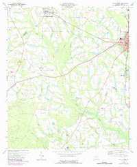
1973 Map of Ocilla West
USGS Topo · Published 1975About this map
Ocilla serves as the focal point of this South Georgia landscape in the early 1970s, where the Seaboard Coast Line railroad skirts the eastern edge of the city. The area exhibits a classic agrarian pattern, with small rural nodes like Mystic and Pinetta connected by a network of local roads and creek systems. Waterways such as Reedy Creek, Little Creek, and Stump Creek drain the undulating terrain, punctuated by family and community landmarks that anchor local history. Religious and educational life is well-represented through institutions like Piney Grove Ch, Old Valley Grove Ch, and Irwin Academy. The map reveals the civic structure of the county seat, highlighting the Courthouse, City Hall, and County High Sch. This survey provides a clear view of the transition from town streets to the surrounding woodland and swampy basins of Jack Creek and Mill Creek.
Find a feature on this map
33 named features on this map. Tap any name to fly to it.
Don’t see what you’re looking for? This feature index may not catch every label — zoom into the map to look around manually.
Map Details
Editions of this 1973 Ocilla West Map
2 editions found
Other maps of this area

1953 · Waycross
USGS Topo · 1:250,000

1958 · Waycross
USGS Topo · 1:250,000

1972 · Fitzgerald East
USGS Topo · 1:24,000

1972 · Ocilla East
USGS Topo · 1:24,000

1973 · Waterloo
USGS Topo · 1:24,000

1973 · Irwinville
USGS Topo · 1:24,000

1973 · Enigma
USGS Topo · 1:24,000

1973 · Tifton East
USGS Topo · 1:24,000

1973 · Fitzgerald West
USGS Topo · 1:24,000
1977 · Alapaha
USGS Topo · 1:24,000