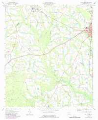
1973 Map of Ocilla West
USGS Topo · Published 1987About this map
Ocilla serves as the focal point of this South Georgia landscape, where the Courthouse and City Hall anchor the local government alongside the County High Sch. To the west, the rural character of Irwin County is defined by a network of creeks and small settlements such as Mystic and Pinetta. The drainage patterns of Little Creek, Reedy Creek, and Stump Creek dictate the placement of local roads and agrarian homesteads. Numerous country churches and cemeteries, including Piney Grove Ch and Fletcher Cem, are scattered throughout the countryside, marking the centers of community life in the early 1970s. The presence of Irwin Academy near the northern border and the Ocilla Country Club near the town center reflect the social infrastructure of the era, while the CSX railroad corridor provides a vital transportation link through the heart of the county.
Find a feature on this map
35 named features on this map. Tap any name to fly to it.
Don’t see what you’re looking for? This feature index may not catch every label — zoom into the map to look around manually.
Map Details
Editions of this 1973 Ocilla West Map
2 editions found
Other maps of this area

1953 · Waycross
USGS Topo · 1:250,000

1958 · Waycross
USGS Topo · 1:250,000

1972 · Fitzgerald East
USGS Topo · 1:24,000

1972 · Ocilla East
USGS Topo · 1:24,000

1973 · Ocilla West
USGS Topo · 1:24,000

1973 · Waterloo
USGS Topo · 1:24,000

1973 · Irwinville
USGS Topo · 1:24,000

1973 · Enigma
USGS Topo · 1:24,000

1973 · Tifton East
USGS Topo · 1:24,000

1973 · Fitzgerald West
USGS Topo · 1:24,000