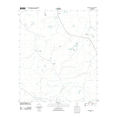
2011 Map of Fitzpatrick
USGS Topo · Published 2011About this map
Fitzpatrick and Mitchell serve as the primary hubs of this landscape, characterized by a complex network of small lakes and agricultural water management systems. The terrain is defined by the winding course of Line Creek and its many tributaries, including Panther Creek and Shopton Branch. A notable concentration of private and community water resources is evident, with named features such as Rutland Lake, Pinkston Lake, and the tandem Lake Forrer Number One and Lake Forrer Number Two. For genealogists and local historians, the presence of the Mount Zion Cemetery and Fitzpatrick Cemetery provides vital clues to the area's settlement history. The road network, including Co RD 37 and Co RD 7, connects these rural communities, while various dam structures like Turnipseed Lake Dam indicate a long-standing reliance on controlled water bodies for local utility or recreation.
Find a feature on this map
32 named features on this map. Tap any name to fly to it.
Don’t see what you’re looking for? This feature index may not catch every label — zoom into the map to look around manually.
Map Details
Editions of this 2011 Fitzpatrick Map
This is the sole edition of this map. No revisions or reprints were ever made.
Other maps of this area

1953 · Montgomery
USGS Topo · 1:250,000

1955 · Phenix City
USGS Topo · 1:250,000

1956 · Montgomery
USGS Topo · 1:250,000

1957 · Phenix City
USGS Topo · 1:250,000

1957 · Montgomery
USGS Topo · 1:250,000

1958 · Phenix City
USGS Topo · 1:250,000

1958 · Mount Meigs
USGS Topo · 1:62,500
1971 · China Grove
USGS Topo · 1:24,000

1971 · Hardaway
USGS Topo · 1:24,000

1971 · Thompson
USGS Topo · 1:24,000