
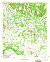
1958 Map of Mount Meigs
USGS Topo · Published 1959About this map
The Tallapoosa River defines the northern reaches of this Montgomery County landscape, winding past numerous archaeological sites including several sets of Indian Mounds and Indian Mound near Hickory Bend Cem. In the late 1950s, this region east of the capital shows a transition from the military presence at Gunter Air Force Base and the VA Hospital to a rural network of farming communities and crossroads. The rail infrastructure is particularly dense here, with the Western Railway of Alabama, Seaboard Air Line, and Central of Georgia all traversing the territory. Notable social hubs include the Alabama Industrial Sch, the Woolley Country Club, and several family-named landmarks like Brassell Bottom and Perrys Mill. Genealogists will find a wealth of burial grounds, from the Old Bingham Cem to the Wares Quarter Cem, documenting the area's deep-rooted settlement history.
Find a feature on this map
117 named features on this map. Tap any name to fly to it.
Don’t see what you’re looking for? This feature index may not catch every label — zoom into the map to look around manually.
Map Details
Editions of this 1958 Mount Meigs Map
2 editions found
Other maps of this area

1901 · Wetumpka
USGS Topo · 1:125,000

1901 · Wetumpka
USGS Topo · 1:62,500

1903 · Wetumpka
USGS Topo · 1:125,000

1906 · Dadeville
USGS Topo · 1:125,000

1927 · Montgomery
USGS Topo · 1:48,000

1930 · Montgomery
USGS Topo · 1:62,500

1953 · Montgomery
USGS Topo · 1:250,000

1955 · Phenix City
USGS Topo · 1:250,000

1956 · Montgomery
USGS Topo · 1:250,000

1957 · Phenix City
USGS Topo · 1:250,000